Posts Tagged ‘Panama’

My first visit to Mamoni Arriba

Thursday, September 30th, 2010

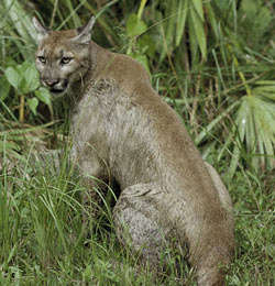
It is easy to quickly recognize the beauty of the Mamoni landscape. Multiple hill tops spread across the landscape were visible from the road to Mamoni Arriba. The surprise I felt laid in the fact that these hills and mountains were fully covered with jungle and not cattle pastures. These days, mountain tops covered with jungle are rare sights in the Panamanian country side, but not in Mamoni. I felt proud and content to be part of this journey into the Mamoni Valley.

I parted from Panamá city early in the morning towards the North East into Mamoni Arriba. My objective was to meet the local people and understand the landscape so that I could plan a longer visit. Luckily for me, I was accompanied by Roland who was born in Mamoni and has been working for Earth Train for many years. I was also accompanied by Carlos Andrés who is a Panamanian lawyer that works for Earth Train and has spent valuable time working in the valley. I had been warned about the access road to Mamoni Arriba because during the rainy season it becomes difficult to ride. However, Rolando’s driving skills did the trick and got us to Mamoni Arriba in no time.

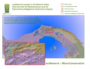
The landscape going down the road and into the Mamoni valley was truly amazing. The valley per say was mostly covered by pasture land. In the background I could see the mountains that surround the valley and that are shared with the Chagres National Park and the Comarca of Kuna Yala. The forest that lies on these mountains is what we in ecoReserve are working to protect. I was imagining myself crossing the mountains to Kuna Yala when Rolando decided to stop at “el filo”. El “filo” is the spot with the highest altitude on the road to Mamoni Arriba. Rolando showed me the Caribbean towards the North. I knew it was the Caribbean because I could clearly see the islands that are part of Kuna Yala. I’ve never visited these islands but now I can say that I’ve seen them from a distance.

Once we made it to Mamoni Arriba we met with Arsenio. Arsenio is a very funny man and with a lot of energy. I wanted him to take me to the forest, to a very “specific spot”! Since I had never been in the valley the only way I could explain to him where I wanted to go was by showing him an aerial photography of Mamoni Arriba. In somewhat of a silly manner he told me that, “he couldn’t understand the image because the highest altitude he had ever seen his house from was 14 meters”. I immediately thought to myself how I had felt the same way the first time I looked for my house on Google earth. I started laughing.

We spend quite sometime figuring out a way to reach the “specific spot” that I wanted to visit. We figured out our starting point for my next visit. The starting point will be where the Espavé stream connects with the Mamoní River. I met with many more people and got a very good feeling for the site.

Field Work Begins in Panama Rainforest!

Wednesday, September 29th, 2010

We are delighted to welcome aboard Mariana Valencia, who will be serving as the Project Launch Coordinator for the ecoReserve-Earth Train project in Panama. Mariana is coming on initially in a 3-month contract position to help set up the logistics for the restoration/conservation project in the Mamoni Valley.

Mariana will be working part-time in Panama City and part-time on the reserve. She will be working on creating access to the reserve, setting up the infrastructure for workers and the nursery, and fleshing out the Program Implementation & Monitoring Plan that was drafted by ecoReserve volunteers this past year (a big thank you to our volunteers: Joan Dudney, Dena Vallano and Yiwei Wang). She will also recruit advisors and identify prospective project staff.

Mariana recently completed a M.S. in Science – Ecology and Evolution Program from the University of Illinois-Chicago (UIC). As a native of the Republic of Panama, she is passionate about forest conservation in Latin America. Her MS thesis led her to work on the restoration of lowland tropical rain forest in Mexico where she worked closely with farmers in restoration projects within rural areas in the Los Tuxtla Biosphere Reserve, Veracruz. She also has interests in working in temperate regions; therefore she developed her MS thesis manuscript on the restoration ecology of prairie systems in Chicago, IL. She is currently preparing her thesis for publication. Mariana received her Bachelor’s degree in Biology, Emphasis in Plant Science at the University of Panama (UP). She worked for three years at the Smithsonian Tropical Research Institute along with scientists of many nationalities in five different sites throughout Panama. Through research and academic courses, she has spent valuable time working in Panama, Mexico, and the USA. These experiences have prepared her to manage and coordinate multiple tasks as well as collaborate with large international research groups. Concerned with the contradictions between economic development and conservation, Mariana is especially interested in working with small landholders on issues of sustainable land use and connecting the economic and ecological aspects of restoration efforts in protected areas.

We are excited to have such a perfectly qualified person as Mariana in this key project launch position. Please welcome Mariana!

ecoReserve Alpha Site is Launched! Beta Up Next!

Thursday, August 12th, 2010

We’re pleased to announce that we now have an alpha version of the ecoReserve website! This is a private site that we’re testing internally but here’s a screenshot of what the *real* Panamanian rainforest looks like!

On the alpha site, you can see all of the available conservation and restoration reserve parcels in the Panamanian rainforest that you’ll help to protect. You can click on the interactive map to adopt your own nature reserve, and your personalized ecoReserve page will display your profile, a portfolio of parcels that you’ve adopted, multimedia content that you’ve uploaded, and messages from your friends. Over the next few weeks, we’ll be refining the alpha site and adding features.

We are now in the final push to launch the public Beta version of the website in the next few weeks.

We will be refining the alpha site and adding several exciting social networking features that will enable micro-conservation to spread rapidly among friends.

We are almost there but we need to raise an additional $20,000 in the next few weeks to launch the site. If just 200 friends like you donate $100 today, we’ll make our goal within 24 hours. Would you please be one of those 200 friends?

If you donate any amount before our Beta launch, you will become one of our Founding Donors honored on the Wall of Fame, and you’ll secure a respected place in ecoReserve’s startup history.

Thank you for your good wishes and support this year. We couldn’t do it without you!

If you’re on Facebook, click here to donate throughCauses.

If you’re not on Facebook, click here to donate through Givezooks.

Chocó-Darien Hotspot

Friday, August 6th, 2010

ecoReserve’s first reserve located in the Mamoni Valley is part of the Tumbes-Chocó-Magdalena Hotspot and includes a small portion of the Chocó/Darién wet region, one of the two major regions in the hotspot.

ecoReserve’s Mamoni Valley reserve falls in two of the 34 internationally recognized biodiversity hotspots: 1) the Mesoamerica Biodiversity Hotspot and 2) the Tumbes-Choco-Magdalena Hotspot. Although both start in Panama, the Mesoamerica Biodiversity Hotspot runs northward, but the Tumbes-Choco-Magdalena Hotspot runs southward. Because we have already discussed the Mesoamerica Biodiversity Hotspot, this post will focus on the Tumbes-Choco-Magdalena Hotspot. The Tumbes-Chocó-Magdalena Hotspot starts in the southeastern portion of Mesoamerica and extends to the northwestern corner of South America with a reach of 1600 kilometers, which is close to 1000 miles. The hotspot is divided into two main regions, the northernmost Chocó/Darién wet and moist forests located in the Darién Province in Panama and the Chocó region in western Colombia to the southernmost Tumbesian dry forests of Ecuador and the northwestern part of Peru.

The Darién Province is one of the most diverse, remote regions in Central America and is protected by dense pristine forests and jungle. At over 3 million acres, it is the largest province in Panama, the most sparsely populated, and the least well known. It is a region of dense tropical rainforest and is among the most complete ecosystems of all tropical America. The Darién is mostly uninhabited mountains, jungle, and swamplands, and it has one of the richest ecosystems of the American tropics. It is also home to many endangered species, such as the jaguar, the giant anteater, the harpy eagle, and the tapir.

Until 20 years ago, there were no roads in the Darién, and travel through the region was very difficult. Before the roads were built, the indigenous people of the area, the Embera, Wounaan, and Kuna, relied mainly on water transportation because they live in settlements scattered along the river valley . Today the Pan-American Highway cuts through the middle of Darien. This gravel highway extends down as far as the town of Yaviza, which is the beginning of the famed Darien Gap. This 100 km gap, which is the only uncompleted piece of the the Pan-American Highway, is impossible for travelers to pass and survive. The highway poses another danger as well. Because the highway connects overland commerce between North and South America, it has opened up the region to cattle ranchers, loggers, and landless peasants. As a result, both the natural forest and the indigenous people of the Darién are being threatened.

The biggest objection to completion of the highway is its effect on the region’s ecological balance and the danger it poses to the survival and habitat of the indigenous people living in the region. It would also extend the already dramatic deforestation of the area.

The Mamoni Valley as Part of the Mesoamerica Biodiversity Hotspot

Wednesday, July 14th, 2010

ecoReserve’s first reserve is located in the Mamoni Valley in Panama and is part of the Mesoamerica Biodiversity Hotspot. Will Cadell, our geospatial engineer, provided a map that shows the location of the Mesoamerica Biodiversity Hotspot and the location of the Mamoni Valley in the hotspot (the red lines delimit outer boundaries of the Mamoni Valley).

Mesoamerica Biodiversity Hotspot


The term biodiversity hotspot refers to 34 biologically rich areas around the world that have lost at least 70 percent of their original habitat. The remaining land in these hotspots amounts to just 1.4 percent of the land surface of the planet, yet these hotspots support almost 60 percent of the world’s plant, bird, mammal, reptile, and amphibian species. The Mesoamerican forests are the third largest among the world’s hotspots. As we discussed in an earlier post, the Mesoamerica Biodiversity Hotspot spans most of Central America, encompassing all subtropical and tropical ecosystems from central Mexico to the Panama Canal and includes the Mamoni Valley.

The Mesoamerica Biodiversity Hotspot is very important for biodiversity as it represents the place where the animals and plants from two regions come together (the Nearctic of North America and the Neotropical of South and Central America). About 3 million years ago, sections of Central America rose above sea level and formed a land bridge between the north and the south. After that occurred, species began to flow in both directions between the continents, and this helped to facilitate Mesoamerica’s unique and diverse variety of animals and plants. Because the mountains that exist in this hotspot are a barrier, there are many differences in both the animals and the plants between the Pacific and Caribbean coasts. However, the valleys and lowlands running parallel to the mountains are natural corridors for animal and human migrations and help facilitate the unique and diverse variety of plants. The Mamoni Valley is an important natural corridor for these animal migrations.

This map provides more detail of the area and the Mamoni Valley, the location of ecoReserve’s first reserve.

Biodiversity includes both flora and fauna (plants and animals endemic to the area). The Mesoamerica Biodiversity Hotspot is home to many animals, including over 400 species of mammals. The Mamoni Valley is home to many of these species of mammals, including the Silky Anteater. The status of the Silky Anteater (Cyclopes didactylus) is vulnerable but going up. Lider Sucre, the director of the Biodiversity Museum, says, “Yes, we have these guys, and they are somewhat common in numbers but HARD to find!! The local name is “Tapacara”, meaning “Face covered”, you can see from the picture that when found they cover their face as if embarrassed.”

Silky Anteater

Our junior researcher reports that they were named for their coat texture and that these guys live in cotton plants, have hooks for claws, and have prehensile tails. Their diet consists of ants, termites, bees, and ladybugs. (They’re immune to the poison.) The silky anteater is only one of the species that lives in the Mesoamerica Biodiversity Hotspot and the Mamoni Valley. There are many more species that are native to the area and need to be protected to ensure their survival.

The Mesoamerican Biological Corridor – What is it, why is it significant?

Thursday, July 8th, 2010

The Mesoamerican Biological Corridor – What is it and why is it significant?

dark green = current reserves | light green = developing reserves

The ecoReserve project in Panama is located within the Mesoamerican Biological Corridor, which is also known as the Jaguar Trail or Path of the Panther.  We thought we’d take a moment to talk about why this is significant.

First, what is a biological corridor (also known as wildlife corridor)?  A wildlife corridor is a route comprising a continuous, or nearly continuous, stretch of open land, woodland or water, which facilitates the movement of wildlife species, the aim of which is to prevent the genetic isolation of wildlife populations.

The Mesoamerican Biological Corridor, specifically, is a large habitat corridor in , stretching from southeastward through most of Central America, connecting several national parks. It was started in 1998 to keep 106 critically endangered species from going extinct.

Mesoamerica is made up of the five southern states of Mexico and the Central American countries of Guatemala, Belize, El Salvador, Honduras, Nicaragua, Costa Rica, and Panama.  These governments agreed to coordinate their efforts to encourage a huge system of interconnected parks, reserves and wildlife corridors that literally link North America to South America.  ecoReserve will be adding one additional reserve to this system.

The Mesoamerican region is very large and covers 768,990 square kilometers. It includes lowland rainforests, pine savannas, semi-arid woodlands, grasslands, high mountain forests, and coral reefs. Although the region contains only 0.5 percent of the world’s land surface, Mesoamerica is home about 7 percent of the earth’s biological diversity.

In recent decades, Mesoamerica has seen some of the highest deforestation rates in the world; between 1980 and 1990, deforestation averaged 1.4 percent annually, and it is estimated that 80 percent of the area’s original habitat has been cleared or severely modified. More than half of Mesoamerica’s forests have been lost and approximately 90 percent of its primary or “frontier” forests have been logged, converted to agriculture, or replaced with tree plantations.

Wildlife corridors become especially important in the face of human activities such as roads, development, or logging that may bisect the routes that animals normally traverse.  Animal movement allows an exchange of individuals between populations, which may help prevent the negative effects of inbreeding and reduced genetic diversity that often occur within isolated populations.

In the Mamoni Valley, where the ecoReserve project will be located, the wildlife corridor has been partially degraded by logging and cattle-ranching which has turned primary forest into pastures or barren dirt.  Animals are reluctant to traverse these open areas because it makes them vulnerable to predators.

ecoReserve will be reforesting and restoring degraded land and protecting primary rainforest that still exists within the Mamoni Valley.  The ecoReserve reserve will also provide a buffer zone for the protected primary rainforest land of the indigenous Kuna that is still intact. We are looking forward to providing one more link in the chain of reserves that protect the famed Jaguar Trail.


ecoReserve and the Mamoni Valley

Wednesday, June 23rd, 2010

In advance of the launch of our new model we wanted to introduce The Mamoni Valley (the site of our first reserves), why it is significant, the ecoReserve model and our ecological strategic contribution in the Valley.

The Mamoni Valley

The Mamoni Valley is located in narrowest portion of the North American continent (central Panama), which separates the Atlantic and Pacific Oceans. The 28000 acre Valley is part of a world recognized biodiversity hotspot and home to a diverse range of plants and animals. In addition, it is an important migration stop-over region for many North and South American birds.

For the past forty years, large areas of the valley have been deforested due to increased demands for agriculture and ranching production. Currently, the Mamoní Valley is severely fragmented and degraded which threatens the watershed and biodiversity.

What is biodiversity?

Biological diversity means the diversity, or variety, of plants and animals and other living things in a particular area or region. For instance, the species that inhabit Los Angeles are different from those in San Francisco, and desert plants and animals have different characteristics and needs than those in the mountains, even though some of the same species can be found in all of those areas. Biodiversity also means the number, or abundance of different species living within a particular region.

Physical Characteristics of the Mamoni Valley and Why It Is Significant

Part of Mesoamerican Biological Corridor: The Mesoamerican Biological Corridor is a large habitat corridor in Mesoamerica, stretching from Mexico southeastward through most of Central America, connecting several national parks. It was started in 1998 to keep critically endangered species from going extinct.

Part of Mesoamerica Biodiversity Hotspot: A biodiversity hotspot is a biogeographic region that is both a significant reservoir of biodiversity and is threatened with destruction. The Mesoamerican forests are the third largest among the world’s hotspots. Spanning most of Central America, the Mesoamerica Hotspot encompasses all subtropical and tropical ecosystems from central Mexico to the Panama Canal. This includes all of Guatemala, Belize, El Salvador, Honduras, Nicaragua, and Costa Rica, as well as a third of Mexico and nearly two-thirds of Panama.

Borders Kuna Yala (land of indigenous Kuna): Kuna Yala is an autonomous territory or comarca in Panama, inhabited by the Kuna indigenous people. The name means “Kuna-land” or “Kuna mountain” in the Kuna language

Borders Chagres National Park: Chagres National Park was established in 1985. The Chagres National Park covers 129,000 hectares and is 40 kilometers from Panama City.

About ecoReserve and The Model

ecoReserve has developed a new model to address the negative social, economic and environmental influences impacting the Mamoní Valley. The model includes three types of reserves, conservation, reforestation and sustainable livelihoods. These reserves will successfully build a multi-faceted, ecological restoration program that increases the health of the rainforest and improves the livelihoods of the people who depend upon the land.

Our ecological strategic contribution by establishing the reserves in the Mamoni Valley:
– Create buffer zone for Kuna Yala and Chagres National Park
– Strengthen biological corridor
– Protect biodiversity and animal habitats

Coming up in upcoming blogs:
Mesoamerican Biological Corridor
Mesoamerican Biodiversity Hotspot
Kuna Yala (land of indigenous Kuna)
Chagres National Park

Pumas – the other large cat of the Panamanian forest

Saturday, June 12th, 2010

If you sense the presence of a large cat while walking in the jungles of Panama, the elusive mountain lion (puma concolor) is probably not the first thing that comes to mind. Its secretive behavior has been a double edged sword, helping it survive the targeted predator hunts of the 19th and 20th centuries but also rendering it far less famous than its distant relative, the jaguar. Despite its relative anonymity, the mountain lion is the only other mammal which has demonstrated the same versatility as humans in conquering the American continents. Evidence of its wide range is reflected in the myriad number of names it has collected over the centuries. The mountain lion that overlooks the Canadian Rockies is the same species as the panther that wanders the jungles of Florida and the puma that scales the Andes of Peru.

Once a member of a guild of large cats which included the American Lion, the American cheetah and the saber-toothed tiger, mountain lions are now the largest wild felid remaining in North America and the second largest in South America. Genetic evidence suggests that North American mountain lions went extinct along with all the other large cats at the end of the Pleistocene 10000 years ago and that North America was reconquered by mountain lions from the south. Thus, the presence of mountain lions in the United States and Canada today speaks to the importance of maintaining linkages such as the Central American Corridor between North and South America.

In North America, male mountain lions weigh around 55-65 kg and females weigh about 40-45 kg. Mountain lions of the tropics tend to be smaller than their temperate counterparts, mostly likely due to environmental influences and possibly because of competition with the sympatric jaguars. Mountain lions are impressive ambush predators that can take down prey as large as a moose and as small as a mouse. Most mountain lions, except females and their kittens, live solitary lives and on vast territories.

In Panama, mountain lions are currently protected from hunting are are not considered endangered by the IUCN. However, the mountain lion’s need for large areas of intact habitat, slow breeding rate, and occasional taste for livestock sometimes brings it into conflict with neighboring human populations. Additionally, large predators, due to their low densities and reliance on prey species, can often be quickly wiped out by people if they are deemed to be a threat. For these reasons, ecoReserve will promote environmental education programs in the Mamoni Valley that will help local residents learn to safely live alongside large cats such as jaguars and mountain lions. By protecting an important habitat corridor, ecoReserve will help maintain the linkage that allows mountain lions to move between the two continents.

Finding the Jaguar Path in Panama: Julia Kumari Drapkin reports from Panama.

Monday, June 7th, 2010

ecoReserve’s initial reserve  in Panama in the Mamoni Valley Preserve borders on Chagres National Park (the northwestern corner of the Mamoni Valley Preserve borders on the Chagres National Park).

National parks around the world provide important refuge for people and wildlife. They’re places where humans can reconnect with the natural world and where animals are protected from human encroachment.

But parks rarely provide enough habitat to ensure the survival of an entire species. This is especially true of large predators like jaguars. Jaguars are the biggest cats in the all of the Americas. And in Central America, scientists are trying to protect Jaguars by finding and protecting the corridors that the cats use as they roam from park to park.

Chagres National Park in Panama is one of these places where the big cat roams. This park is located on the eastern side of the Panama Canal, between the provinces of Panama and Colon. With a surface of 129,000 hectares (300,000 acres), this park was created to protect the tropical rainforest around the rivers that run through it and which are the main source of water for the Panama Canal.

Learn about jaguar protection work in Panama in Chagres National Park

This park was created with the objective of preserving the natural forest of which it consists, in order to produce water in sufficient quantities and of adequate quality to guarantee normal operations of the Panama Canal, as well as supplying drinking water to the cities of Panama, Colon and La Chorrera and at the same time generating electricity for Panama and Colon.

This area is home to species such as the:

  • Jaguar
  • Mantled howler monkey
  • Northern tamandua (anteater)
  • More than 560 bird species are found in the Alto Chagres region.

Scientists at Panthera will create a map of so-called jaguar corridors. But even as Olmos discovers these jaguar corridors, they’re already being severed by new human ones. A multilane highway is under construction right between the parks. It’s not just the highway itself that poses a threat to jaguars but the development it’s likely to bring. More access, brings more people, more houses, more stores.

Endangered, but going up, still found in Madrono

Wednesday, May 26th, 2010

Name: Kinkajou (Potos flavus)
Status: Endangered, but going up

Our junior researcher says:  “These cuddly critters are related to raccoons, have 5in. tongues, and prehensile tails. Their diet consists of honey, nectar, fruit pulp, and insects.

From  Panama, Lider Sucre, director of Panama’s Museum of Biodiversity:

“Kinkajous endangered!?! These guys are quite common, though nocturnal and thus not often seen.  We have them right around Madroño for sure.  The local name is “Jujuná”, but the same name is used sometimes for night monkeys because their size and habits are somewhat similar.”

How important is it to protect the Kinkajou, an endangered animal,  in Madroño, our reserve in Panama, where they are  found living in the wild?   We think very important and hope you do to.