Posts Tagged ‘Kuna’

My first visit to Mamoni Arriba

Thursday, September 30th, 2010

It is easy to quickly recognize the beauty of the Mamoni landscape. Multiple hill tops spread across the landscape were visible from the road to Mamoni Arriba. The surprise I felt laid in the fact that these hills and mountains were fully covered with jungle and not cattle pastures. These days, mountain tops covered with jungle are rare sights in the Panamanian country side, but not in Mamoni. I felt proud and content to be part of this journey into the Mamoni Valley.

I parted from Panamá city early in the morning towards the North East into Mamoni Arriba. My objective was to meet the local people and understand the landscape so that I could plan a longer visit. Luckily for me, I was accompanied by Roland who was born in Mamoni and has been working for Earth Train for many years. I was also accompanied by Carlos Andrés who is a Panamanian lawyer that works for Earth Train and has spent valuable time working in the valley. I had been warned about the access road to Mamoni Arriba because during the rainy season it becomes difficult to ride. However, Rolando’s driving skills did the trick and got us to Mamoni Arriba in no time.

The landscape going down the road and into the Mamoni valley was truly amazing. The valley per say was mostly covered by pasture land. In the background I could see the mountains that surround the valley and that are shared with the Chagres National Park and the Comarca of Kuna Yala. The forest that lies on these mountains is what we in ecoReserve are working to protect. I was imagining myself crossing the mountains to Kuna Yala when Rolando decided to stop at “el filo”. El “filo” is the spot with the highest altitude on the road to Mamoni Arriba. Rolando showed me the Caribbean towards the North. I knew it was the Caribbean because I could clearly see the islands that are part of Kuna Yala. I’ve never visited these islands but now I can say that I’ve seen them from a distance.

Once we made it to Mamoni Arriba we met with Arsenio. Arsenio is a very funny man and with a lot of energy. I wanted him to take me to the forest, to a very “specific spot”! Since I had never been in the valley the only way I could explain to him where I wanted to go was by showing him an aerial photography of Mamoni Arriba. In somewhat of a silly manner he told me that, “he couldn’t understand the image because the highest altitude he had ever seen his house from was 14 meters”. I immediately thought to myself how I had felt the same way the first time I looked for my house on Google earth. I started laughing.

We spend quite sometime figuring out a way to reach the “specific spot” that I wanted to visit. We figured out our starting point for my next visit. The starting point will be where the Espavé stream connects with the Mamoní River. I met with many more people and got a very good feeling for the site.

Chocó-Darien Hotspot

Friday, August 6th, 2010

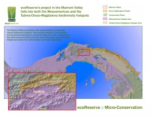
ecoReserve’s first reserve located in the Mamoni Valley is part of the Tumbes-Chocó-Magdalena Hotspot and includes a small portion of the Chocó/Darién wet region, one of the two major regions in the hotspot.

ecoReserve’s Mamoni Valley reserve falls in two of the 34 internationally recognized biodiversity hotspots: 1) the Mesoamerica Biodiversity Hotspot and 2) the Tumbes-Choco-Magdalena Hotspot. Although both start in Panama, the Mesoamerica Biodiversity Hotspot runs northward, but the Tumbes-Choco-Magdalena Hotspot runs southward. Because we have already discussed the Mesoamerica Biodiversity Hotspot, this post will focus on the Tumbes-Choco-Magdalena Hotspot. The Tumbes-Chocó-Magdalena Hotspot starts in the southeastern portion of Mesoamerica and extends to the northwestern corner of South America with a reach of 1600 kilometers, which is close to 1000 miles. The hotspot is divided into two main regions, the northernmost Chocó/Darién wet and moist forests located in the Darién Province in Panama and the Chocó region in western Colombia to the southernmost Tumbesian dry forests of Ecuador and the northwestern part of Peru.

The Darién Province is one of the most diverse, remote regions in Central America and is protected by dense pristine forests and jungle. At over 3 million acres, it is the largest province in Panama, the most sparsely populated, and the least well known. It is a region of dense tropical rainforest and is among the most complete ecosystems of all tropical America. The Darién is mostly uninhabited mountains, jungle, and swamplands, and it has one of the richest ecosystems of the American tropics. It is also home to many endangered species, such as the jaguar, the giant anteater, the harpy eagle, and the tapir.

Until 20 years ago, there were no roads in the Darién, and travel through the region was very difficult. Before the roads were built, the indigenous people of the area, the Embera, Wounaan, and Kuna, relied mainly on water transportation because they live in settlements scattered along the river valley . Today the Pan-American Highway cuts through the middle of Darien. This gravel highway extends down as far as the town of Yaviza, which is the beginning of the famed Darien Gap. This 100 km gap, which is the only uncompleted piece of the the Pan-American Highway, is impossible for travelers to pass and survive. The highway poses another danger as well. Because the highway connects overland commerce between North and South America, it has opened up the region to cattle ranchers, loggers, and landless peasants. As a result, both the natural forest and the indigenous people of the Darién are being threatened.

The biggest objection to completion of the highway is its effect on the region’s ecological balance and the danger it poses to the survival and habitat of the indigenous people living in the region. It would also extend the already dramatic deforestation of the area.

ecoReserve and the Mamoni Valley

Wednesday, June 23rd, 2010

In advance of the launch of our new model we wanted to introduce The Mamoni Valley (the site of our first reserves), why it is significant, the ecoReserve model and our ecological strategic contribution in the Valley.

The Mamoni Valley

The Mamoni Valley is located in narrowest portion of the North American continent (central Panama), which separates the Atlantic and Pacific Oceans. The 28000 acre Valley is part of a world recognized biodiversity hotspot and home to a diverse range of plants and animals. In addition, it is an important migration stop-over region for many North and South American birds.

For the past forty years, large areas of the valley have been deforested due to increased demands for agriculture and ranching production. Currently, the Mamoní Valley is severely fragmented and degraded which threatens the watershed and biodiversity.

What is biodiversity?

Biological diversity means the diversity, or variety, of plants and animals and other living things in a particular area or region. For instance, the species that inhabit Los Angeles are different from those in San Francisco, and desert plants and animals have different characteristics and needs than those in the mountains, even though some of the same species can be found in all of those areas. Biodiversity also means the number, or abundance of different species living within a particular region.

Physical Characteristics of the Mamoni Valley and Why It Is Significant

Part of Mesoamerican Biological Corridor: The Mesoamerican Biological Corridor is a large habitat corridor in Mesoamerica, stretching from Mexico southeastward through most of Central America, connecting several national parks. It was started in 1998 to keep critically endangered species from going extinct.

Part of Mesoamerica Biodiversity Hotspot: A biodiversity hotspot is a biogeographic region that is both a significant reservoir of biodiversity and is threatened with destruction. The Mesoamerican forests are the third largest among the world’s hotspots. Spanning most of Central America, the Mesoamerica Hotspot encompasses all subtropical and tropical ecosystems from central Mexico to the Panama Canal. This includes all of Guatemala, Belize, El Salvador, Honduras, Nicaragua, and Costa Rica, as well as a third of Mexico and nearly two-thirds of Panama.

Borders Kuna Yala (land of indigenous Kuna): Kuna Yala is an autonomous territory or comarca in Panama, inhabited by the Kuna indigenous people. The name means “Kuna-land” or “Kuna mountain” in the Kuna language

Borders Chagres National Park: Chagres National Park was established in 1985. The Chagres National Park covers 129,000 hectares and is 40 kilometers from Panama City.

About ecoReserve and The Model

ecoReserve has developed a new model to address the negative social, economic and environmental influences impacting the Mamoní Valley. The model includes three types of reserves, conservation, reforestation and sustainable livelihoods. These reserves will successfully build a multi-faceted, ecological restoration program that increases the health of the rainforest and improves the livelihoods of the people who depend upon the land.

Our ecological strategic contribution by establishing the reserves in the Mamoni Valley:
– Create buffer zone for Kuna Yala and Chagres National Park
– Strengthen biological corridor
– Protect biodiversity and animal habitats

Coming up in upcoming blogs:
Mesoamerican Biological Corridor
Mesoamerican Biodiversity Hotspot
Kuna Yala (land of indigenous Kuna)
Chagres National Park